


S U M M A R Y
Contact us via e-mail
maria@dnt.ro
mzoran@inoe.ro
V R A G E O
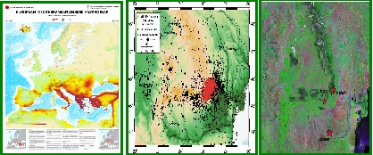
VRAGEO is a service proposed in response to Partnerships Program - Applied Research Projects - Competition 2013, Priority area 3- Environment, Research direction 3.4.6. Natural and technological hazards; researches on risk assessment and impact studies. The main objective of VRAGEO is to enable free and open access to seismic hazard information in Romania due to Vrancea source in support of GMES (Global Monitoring of Environment and Security) through the development of an operational framework, a set of supporting tools and advanced geospatial surveillance methodologies of Vrancea tectonic active region.VRAGEO takes a closer look at geophysical activity anomalies in Vrancea and its surroundings, providing timely information to limitate negative impacts. Through the development of a strong geodata base of in-situ and geospatial data, new methods and indicators for improving seismic hazard assessment in Romania, VRAGEO will demonstrate to which extent a systematic integration of several independent observations can improve medium and short-term earthquake prediction. For monitoring of the geophysical parameters havingprecursory character in Vrancea area time-series geospatial data will be used in three distinct directions: 1)Preseismic crustal deformation with millimeters-centimeters precision order through GPS, LEVELLING network and radar satellite interferometry (TerraSARX, ALOS, future Sentinels); 2)Geomagnetic and Ionospheric anomalies, short term or immediate seismic precursors over strong earthquakes areals expressed through Total Electron Content TEC provided by GPS permanent network stations or from real-time IPS - WDC for Solar-Terrestrial Science data; 3)Possible thermal surface anomalies inferred through surface latent heat flux (SLHF) and Land Surface Temperature (LST) changes from time-series satellite data in IR regions (NOAA-AVHRR, Terra/Aqua-MODIS, Landsat TM/ETM, ENVISAT, Sentinels). Will be quantified long-, medium-, short- and immediateterm of geophysical parameters and radon concentration variations, sensitive to seismic events. Information derived from time-series satellite data will be used in synergy with in-situ monitoring data provided by geophysical, geodetic, geodynamic, electromagnetic, solar,seismic, meteorological monitoring networks of Romania. Will be adapted and developed Lithosphere-Atmosphere-Ionosphere and Plate Kinematic Models applied for crustal movements and seismicity in Vrancea area for location and increasing geophysical activity in Vrancea zone will be cross-validate with in-situ and geospatial data. VRAGEO will improve the seismic hazard assessment in Vrancea zone through providing of different levels of experimental seismic hazard services for users:Seismic Hazard Mapping Service,Geophysical Parameters Service Mapping and Geophysical Parameters Anomalies Detection Mapping Service. For analysis of geophysical processes at the ground-to-air and ground-to-water interfaces responsible for seismic presignals generation, will be refined existing methodologies and developed new different advanced monitoring and surveillance methodologie, will be modeled the geodynamical processes and will be cross-validated with in-situ data. In order to mitigate-improve the preparedness of strong Vrancea earthquake in Romania,VRAGEO promotes applied inter- and multi-disciplinary approach by the development of a research dissemination Seismic Hazard Information Platform at all society levels to support spatial and policy planning in the context of global change and societal advance.VRAGEO will develop of a novel seismic hazard assessment strategy, combining high-resolution remote sensing with a numerical modeling approach and will generate intelligent knowledge to deliver new and more innovative products, processes and services for Vrancea seismic area. The VRAGEO is set to develop state-of-the-art service capabilities for enhanced seismic hazard and risk services, especially addressing national needs.
Copyright 2014 INOE 2000. All rights reserved. made by Defiler
INTEGRATED SEISMIC HAZARD INFORMATION PLATFORM FOR VRANCEA ZONE SURVEILLANCE THROUGH ADVANCED GEOSPATIAL AND IN-SITU METHODOLOGIES
National Institute for Reasearch and Development for Optoelectronics - INOE 2000 www.inoe.ro